Coyote Graphics Map Projection Programs
These are programs from the Coyote Library that are specifically
identified as being associated with map projections. On-line
documentation for these programs is available.
A number of program examples using Coyote Map routines can be found in the
Coyote Plot Gallery.
Alphabetical List of Programs
- cgCBAR2KML Creates a color bar for KML files in Google Earth.
- cgCHANGEMAPPROJECTION Warps an
image in one map projection to another.
- cgCLIPTOMAP Clip or subset a georegistered image to a map boundary.
- cgDRAWSHAPES A program to draw shapefile polygons on map projections.
- cgEXTRACTSHAPE Extracts a single shape or polygon from a shapefile.

- cgFINDMAPBOUNDARY Finds the the boundary of the map projected grid for files that allow it.
- cgGEOMAP Automatically georegisters a GeoTiff image.
- cgIMAGE2KML Creates a KML file
to overlay an image in Google Earth.
- cgKML2KMZ Package KML and image files into a KMZ compressed zip file.
- cgGOOGLE_METERSPERPIXEL Calculates meters per pixel value for Google Static Maps.
- cgGOOGLEMAPMARKER__DEFINE Defines a marker structure for Google Static Maps.
- cgGOOGLEMAPWIDGET A compound object-widget for adding Google Static Maps to an application.
- cgGOOGLEMAPWIDGET__DEFINE The cgGoogleMapWidget object.
- cgMAP_CONTINENTS A Coyote Graphics wrapper for Map_Continents.
- cgMAP_GRID A Coyote Graphics wrapper for Map_Grid that fixes a number of problems.
- cgMAP_GSHHS Draws outlines from the GSHHS shoreline data on maps.
- cgMAP_SET A Coyote Graphics wrapper for Map_Set.
- cgMAP A more powerful means of creating and using GCTP map projections.
- cgMAPCONTINENTS An object wrapper for cgMap_Continents and cgMap_GSHHS.
- cgMAPGRID An object wrapper for cgMap_Grid.
- cgMAPPLOTS Draws lines and symbols on map projections set up with cgMap.
- cgMAPVECTOR Draws vectors (arrows) on map projections set up with cgMap.
- cgNCDFMAP Creates a map coordinate object for netCDF files with map projections.
- cgSHAPEINFO Allows the user to browse shapefiles containing geographical information.
- cgTERMINATORMAP Creates a day/night map terminator on a map projection.
- cgUTMZONE Returns the UTM zone for a particular longitude and latitude.
- cgWARPTOMAP Allows mapping of data with associated latitude and longitude arrays.


|
|
|
The purpose of this program is to create a KML file containing a
"ScreenOverlay" element that can be opened in Google Earth to display
a color bar. Screen overlays are located at a stationary position on
the Google Earth display, which the 3D Earth rotates and zooms beneath it.
Screen overlays can be made visible and invisible, as needed.
   kmlFile = Obj_New('cgKML_File', 'avhrr_ndvi_cb.kml')
   cgLoadCT, 11, /Brewer, /Reverse, RGB_Table=palette
   map = cgGeoMap('AF03sep15b.n16-VIg.tif', Image=image)
   scaledImage = BytScl(image > 0)
   cgImage2KML, scaledImage, map, $
          Palette=palette, Missing_Value=0, $
          Description='AVHRR NDVI Data from Africa', $
          PlaceName='AVHRR Africa', $
          AddToFile=kmlFile
   cgCBar2KML, Palette=palette, Range=[0,9400], $
          Title='NDVI Index', $
          Description='AVHRR NDVI Color Bar', $
          PlaceName='NDVI Color Bar', $
          AddToFile=kmlFile
   kmlFile -> Save
   kmlFile -> Destroy
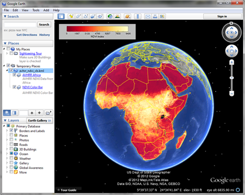 |
| An AVHRR NDVI image with a color bar overlaid on Google Earth. |
|
|
|
|
This is a utility program that warps an image in one map projection to another
map projection, using Map_Proj_Image. The input and output map projections are
specified using the map coordinate object cgMap. The program
is especially useful in converting map projected images into the map projection
required to create image overlays in Google Earth.
|
|
|
|
This is a utility program that allows the user to clip or subset a georegistered image (i.e.,
one with an associated map coordinate object) to a map boundary. It is useful when comparing
two images with different map ranges and/or pixel resolutions. This works particularly well
with GeoTiff images.
|
|
|
|
The purpose of this program is to draw shapefile polygons and
polylines on map projections.
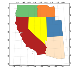 |
| States from a states shapefile are displayed. |
|
|
|
|
This utility routine finds the map projection grid boundary from a file,
if it is possible to do so. Currently works with GeoTIFF files, CF 1.4
compliant netCDF files, and GPD files created with the GPD_Viewer software
from the Catatlyst Library.
|
|
|
|
The purpose of this program is to create a KML file containing a
"GroundOverlay" element that can be opened in Google Earth to drape
an IDL image over the Google Earth terrain. Map coordinates locate
the image overlay on the Google Earth map. For example, the following
command creates a KML file that overlays an AVHRR NDVI image of Africa
when opened in Google Earth.
   cgImage2KML, GeoTiff='AF03sep15b.n16-VIg.tif', Min_Value=0, CTIndex=11, $
      /Brewer, /Reverse, Transparent=50, Filename='avhrr_ndvi.kml', $
       Description='AVHRR NDVI Data from Africa'
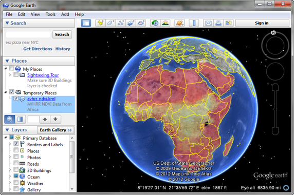 |
| An AVHRR NDVI image of Africa overlaid on Google Earth. |
|
|
|
|
This program packages KML files and their associated image files up into a compressed KMZ zip file that can be loaded into Google Earth. The method uses
an unofficial unvailing of the zip API in IDL for cross-platform zipping of files.
IDL 8.1 or higher is required to use this functionality.
|
|
|
|
The purpose of this function is to translate a GeoTiff structure
(as returned by Query_Tiff or Read_Tiff) into a map coordinate object
(cgMap) that can be used to georeference images with a map data
coordinate system. If desired, the GeoTiff image can be displayed
in a georegistered resizeable graphics window directly.
|
|
|
|
This is a utility routine that can be used to calculate the number of meters
per pixel in a Google Static Image Map with a given zoom level. This value is
required to set up a map coordinate system for the static image map. Setting up
a coordinate system (via a cgMap object) is what allows the user to draw on
top of the static image map.
|
|
|
|
This is a structure definition routine for a Goggle map marker structure that is
used to create map markers for display on Google Static Maps. Used with the
cgGoogleMapWidget
compound widget-object.
|
|
|
|
This is a compound widget-object for incorporating a Google Static Image Map
into a widget application. The program implements a subset of the
Google Static
Map API. The
program works by building a URL for a map image. A connection to the Internet is
required to then request a map image (in GIF, JPEG or PNG format) to be returned from
Goggle Maps. The returned image is then read and loaded into a draw widget window
of the right size for the returned map image. The default is to delete the image file
that is created, but user can also set keywords to retain the image that is downloaded
from Google Maps. Users are able to control button and motion events in the resulting
draw widget with their own event handler module. A cgMap
coordinate object is created
to establish a map reference coordinate system on top of the returned map image, allowing
other map information to be drawn on top of the returned map image.
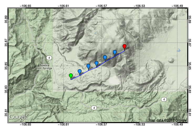 |
| A Google Static Image Map with a lidar track displayed on top of it.
Google markers are placed every 5 seconds. |
|
|
|
|
This is the implementation of the cgGoogleMapWidget described above. If called by
itself, it will create its own top-level base widget and can be used as a stand-alone
application. However, it is more likely that users will want to use their own event
handlers to draw on to of the image returned from Google. Provisions for doing that
are built into the object.
|
|
|
|
The purpose of this object is to provide a simple wrapper to the Map_Continents command
that is used to draw continental outlines on maps. It uses the device and color-model independent
Coyote Graphics commands internally, and can be added to a cgWindow by setting the AddCmd keyword.
|
|
|
|
The purpose of this object is to provide a simple wrapper to the Map_Grid command
that is used to draw grid line on maps. It uses the device and color-model independent
Coyote Graphics commands internally, and can be added to a cgWindow by setting
the AddCmd keyword. Many of the problems with Map_Grid, and especially problems
caused by using Map_Grid with GCTP map projections, have been corrected in this routine.
|
|
|
|
This program uses files from the Globally Self-consistent Hierarchical High-resolution Shoreline
(GSHHS) data base to draw shorelines in the manner of cgMap_Continents. In other words,
it is assumed that a map coordinate data space has been established prior to calling
this routine. See the example below. The GSHHS data files are
available for downloading.
An article describing how to use this
program is also available.
Note, the authors of the GSHHS software continually change the header
structure, which you must know to read the data file. There are are now
at least four different structures in common use. Please find the one
you need from the commented list in the code itself. The current code uses the structure
for the 2.2 version of the GSHHS software.
|
|
|
|
This program provides a modified Map_Set command that can work together with
other Coyote Graphics commands and be used in or added to resizeable graphics windows.
Any keyword appropriate for Map_Set can be used with this routine.
|
|
|
|
The purpose of this object is to provide an easy and powerful way to
set up and use a map coordinate space created by the GCTP map projections
accessed by Map_Proj_Init. The program is basically a wrapper for
Map_Proj_Init, combined with a cgCoord data coordinate object, to provide
a way to set up and maintain a map coordinate space. Overlay objects can be
add to cgMap to
draw graphics in the map coordinate space as well. Typically, continental outlines
and map grid lines are added, and these two overlays can be selected by appropriate
keywords. This object can be added to a cgWindow by selecting either the Window or
AddCmd keyword.
|
|
|
|
This program provides an object wrapper to the cgMap_Continents
and cgMap_GSHHS
commands. It can be used as an overlay object in the cgMap object, or as
a stand-alone graphics object for drawing continental and country outlines on maps.
|
|
|
|
This program provides an object wrapper to the cgMap_Grid
command. It can be used as an overlay object in the cgMap object, or as
a stand-alone graphics object for drawing grid lines on maps.
|
|
|
|
This program allows the user to draw lines and symbols on map projections set up
with cgMap.
|
|
|
|
This program allows the user to draw vectors (arrows) on map projections set up
with cgMap.
|
|
|
|
This program can create a map coordinate object from map projection information
stored in netCDF files. Not all netCDF files contain enough information to create
a map projection space in IDL, but many do. If it can be done, this program will do it!
|
|
|
|
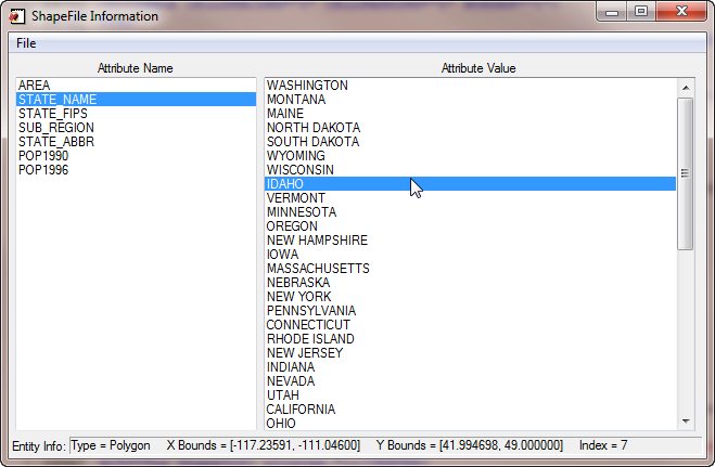
The purpose of this program is to allow the user to browse a very narrow
selection of shapefiles. Namely, those containing geographical shapes
in latitude and longitude coordinates. In other words, shapefiles
containing maps. File attributes are listed in the left-hand list
widget. Clicking on a file attribute, will list all the entity
attributes for that file attribute in the right-hand list. Clicking
an entity attribute with list the type of entity, and the X and Y
bounds of that entity (shown as LON and LAT, respectively), in the
statusbar at the bottom of the display.
Knowing the attribute and entity names of a shapefile will give
you insight into how to read and display the information in the file.
For examples, see the Coyote Library programs DrawCounties and DrawStates.
|
|
|
|
This is a program for viewing a map of the Earth in several different
projections with a day/night terminator. The program uses routines from
the
JHUAPL IDL Library, which must also be on your IDL path, along with
the Coyote Library.
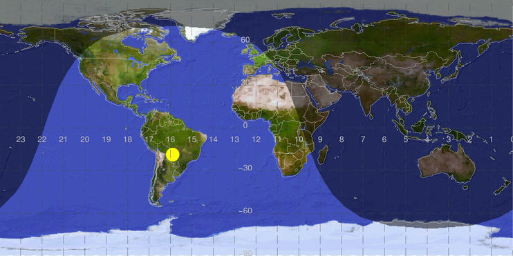 |
| A map with a day/night terminator. |
|
|
|
|
This function returns the correct UTM zone for a given longitude and latitude
value. Note that the exceptions to the UTM zones in the Svalbard area are not
currently supported. The user will be notified of this fact, if needed.
|
|
|
|
This function warps data that is in either a 1D or 2D array, with associated
latitude and longitude values, into a map projection. It is the Coyote Graphics
equivalent of the IDL function Map_Patch. You can learn how to use this function
by reading the article Mapping Data Associated
with Lat/Lon Arrays.
|
Version of IDL used to prepare this article: IDL 7.0.1.
Copyright ©
1996–2018 Fanning Software Consulting, Inc.
Last Updated: 16 November 2011


